The Stones of Greece
Thessaly
Google-Map
Theopetra
Cave***
48 000 - 3000
BC
Paleleolithic-Neolithic Site
9
km southeast of Kalambaka (Meteora)
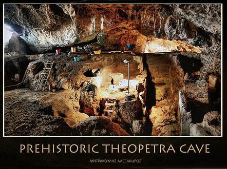
Theopetra Cave during excavations,
Price-winning photo by Alex
Mitrakoulis, flickr.com
On the road from Trikala to Kalambaka, 3 kilometres before reaching Meteora, a huge lime rock rises above the village of Theopetra. On its northwesternt side there is a cave bearing the same name. It is a prehistoric site situated in the western part of the Thessalian plain, at the foot of the Chasia mountain chain, the natural boundary between Thessaly and Epirus.
The cave is situated approximately 100 metres
above the surface of the plain and 280 metres above sea level.
The Lithaios River, a tributary of the Peneios River, flows in front
of the cave. The mouth of the cave is 17 x 3 metres whereas its main
chamber, measuring 500 square metres, is rectangular and has side
niches.
Text: ime.gr/chronos
The 6 metre deep sequence of archaeological deposits in Theopetra
Cave witnessed intermittent hominid occupation from the early Upper
Pleistocene, 50,000 years ago, through to the abandonment of the cave
as a place of settlement in the Chalcolithic, at about 3000 BC. The
chronology of occupation in the cave is well established through more
than 50 radiocarbon dates, catalogued in this volume by Facorellis
and Maniatis (the dates were subsequently published in the journal
Radiocarbon by Facorellis et al., 2001). The copious artefactual and
environmental evidence from the cave is augmented by human remains
from burials dated to 14,500 and 7,000 BC, as well as a unique set of
footprints that were possibly made by Neanderthals.
From a Book
Review: "Theopetra Cave. Twelve Years of Excavation and
Research 1987-1998."
Edited by Nina Kiparissi-Apostolika.
Institute for Aegean Prehistory, Athens, 2000.
For another cave
with similarly long human record see Franchthi Cave in the
southern Argolis (20 000- 3000 BC)
Petralona
Cave (Macedonia)
200 000-300
000 BC
Southeast of Thessaloniki
A skull supposedly from 70 000 BC was found here. more likely it is from 300 000 to 200 000 BC. Controversy surrounds the interpretation of this cranium, and it has been variously classified as Homo erectus, as a classic Neanderthal (Homo neanderthalensis), and as an early representative of Homo sapiens sapiens in a generalized sense (Day 1986: 91-95). The consensus among paleoanthropologists today is that the cranium belongs to an archaic hominid distinguished from Homo erectus and from both the classic Neanderthals and anatomically modern humans (Day 1986: 95; Stringer, Howell, and Melenitis 1979).... Whatever the final classification may be, the cranium has been provisionally dated to ca. 200-400 kyr (Day 1986: 94 Hennig et al. 1981, 1982; Wintle and Jacobs 1982), and it is thus possible that the Petralona hominid represents the lineage responsible for the Thessalian Lower Paleolithic sites.
A Greek Story
The Petralona Cave and Anthropological Museum is
privately owned by the "Anthropological Association of Greece",
founded and first presided over by Aris Nickos Poulianos then by his
son, who have held the concession for the exploration of the cave
since the beginning of the 1960s. Poulianos from Ikaria, in his youth
a member of ELAS and the DSE,
later with a doctorate in Anthropology from Moscow, named the hominid
scull Archanthropus europeaus petraloniensis, and estimated
its age to be around 700,000 years old!
From aee.gr
and Aris
Poulianos, Wikipedia
Franchthi
Cave (Argolis)*
20 000-3000
BC
Argolis
The cave was occupied from the Palaeolithic circa 20,000 BCE (and possibly earlier) through the Mesolithic and Neolithic periods, being abandoned about 3000 BCE (Middle Neolithic). It is one of the very few settlements in the world that shows continuous human occupation for more than 20,000 years.
It also contains some of the earliest evidence for agriculture in
Greece. The first inhabitants were probably hunter gatherers, but
from around 11,000 BCE almonds, pistachios, bitter vetch, and lentils
all appear at the same time, while wild oats and wild barley appear
from 10,500 BCE, while from 7,300 BCE peas and wild pears also
appear. None appear to be native to the region, while two are
certainly from Asia Minor. This would seem to indicate that the
farming of legumes and nuts preceded that of grain in Greece, if not
in Asia Minor at least. This would make this area the oldest known
agricultural site in Greece.
Wikipedia
A
detailed and informed article on Paleo/Neolithic
Caves in Greece
Neolithic
Sites in Greece – Sesklo**
6500
- 3200 BC
Neolithic sites in Greece, ime.gr/chronos
Sesklo gives its name to the first Neolithic culture of Europe, which inhabited Thessaly and parts of Greek Macedonia. The oldest fragments researched at Sesklo place the civilization's development as far back as 6850 BC with a +/- 660 year margin of error (uncorrected radiocarbon). The first settlements, which predate the 6th millennium BC, are referred to as proto-Sesklo (main group) and pre-Sesklo (secondary groups with differentiated characteristics) and they show an advanced agriculture and a very early use of pottery that rivals in age those of the Near East, especialy Anatolia in an area geographically close to the Petralona cave and the Archanthropus living environment.
The peoples of Sesklo built their villages on hillsides near fertile valleys, where they grew wheat and barley, also keeping herds of mainly sheep and goats, though they also had cows, pigs and dogs. Their houses were small, with one or two rooms, built of wood or mudbrick in the early period. Later the construction technique becomes more homogeneous and all homes are built of adobe with stone foundations. In the 6th millennium BC, the first houses with two levels are found and there is also a clear intentional urbanism.
The culture of Sesklo is crucial in the expansion of the Neolithic into Europe. Dating and research brought out the similarities between Sesklo and the Starčevo cultures of Serbia. Beyond modern national boundaries together they form the first Neolithic culture of the Old Europe, which is, as Gimbutas has pointed out, distinct from Anatolia. At least in part the late Neolithic Old Europe seems to have spread from this complex.
Archeological finds and dates show that the Sesklo culture lasted
only until 5000 BC when it was violently conquered by people of the
Dimini culture. The "invasion theory" maintains that the
Dimini culture is different from that found at Sesklo. However,
Professor Ioannis Liritzis provides a more detailed analysis of the
late "Seskloans". He, along with R. Galloway, compared
ceramic materials from both Sesklo and Dimini utilizing
thermoluminescence dating methods. He discovered that the inhabitants
of the settlement in Dimini appeared around 4800 BC, four centuries
before the fall of the Sesklo civilization (ca. 4400 BC). Lyritzis
concluded that the "Seskloans" and "Diminians"
coexisted for this period in time.
With modifications from
Wikipedia
More
informative and images,etc.: Neolithic
Greece, ime.gr.com
Achilleion
(Thessaly)
6500-5800 BC
south
of Farsala
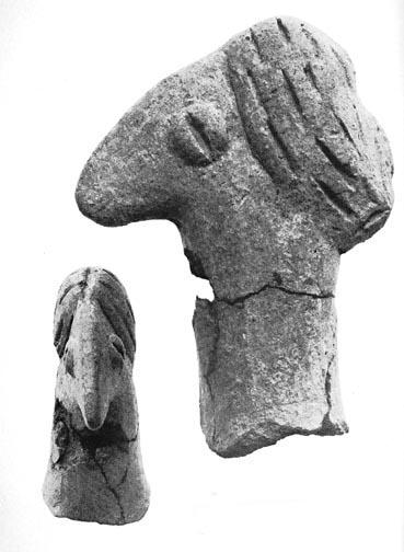
The Goddess in her bird incarnation, 6000 BC, found at
Achilleion
image from Marija Gimbutas "Goddesses and Gods
of Old Europe", Univ. California, 1982
Achilleion is an early Neolithic site in Thessaly. It was excavated
by the American archaeologist Marija Gimbutas in 1973-1983, and has
been Carbon-14 dated (dendrochronologically corrected) to between
6500 and 5000 BC
Marija Gimbutas "Achilleion: A Neolithic
Mound in Thessaly; Preliminary Report on 1973 and 1974 Excavations",
Journal of Field Archaeology, Vol. 1, No. 3/4 (1974), pp. 277-302
Sesklo
A**
Neolithic 7000-4000 BC
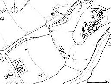
Plan of Sesklo A and B from HMTC Odysseus
Two villages have been unearthed in the vicinity; Sesklo A and Sesklo B. Sesklo A occupies the crown of Kastraki hill, and Sesklo B has been unearthed further to the southwest at a lower elevation
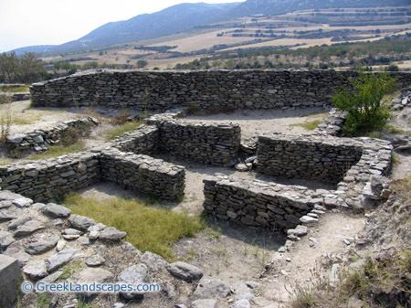
Middle Neolithic Megaron, Photo
The ruins of the Middle Neolithic megaron with its two rooms clearly
visible. Large Neolithic buildings with two chambers are commonly
called "megaron" that implies the residence of a leader,
even though their use is unknown. These structures that were usually
larger than the rest, and built in the middle of the settlement,
could be also a communal space, or even a place of worship (their
general outline resembles a later Greek temple). Visible at the
background of this photo, is the impressive wall that supported the
much larger later megaron which was built in the Late Neolithic
period.
Photo and Text from Greek
Landscapes
Sesklo
B**
5000-4000 BC
Sesklo B is the settlement excavated on the western slope of the Kastraki hill where Sesklo A is located. Sesklo B is a Middle Neolithic settlement, contemporary in part to Sesklo A, and is part of an extensive network of Neolithic settlements in the extended area. It is much less attractive for the casual visitor, but it can be seen in the same visit.
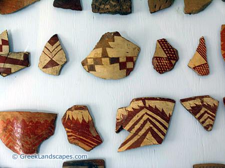
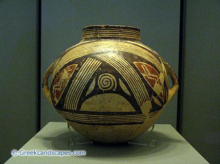
Characteristic pottery shards from Sesklo (5th millenium BC!)
Photos and Text from Greek Landscapes
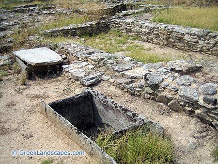
Dimini**
Late
Neolithic II to Late Mycenean 4800-1400 BC
near Volos,
Thessaly
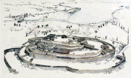
Reconstruction of the late Mycenian settlement at Dimini 1400 BC
Polychrome pottery from the late Neolithic part of Dimini (before 4500 BC)
The site of Dimini covers an area of ca. 5000 sq. m and flourished during the Thessalian Late Neolithic period (ca. 4800 - 4000 B.C.). It is considered to have been inhabited by two separate people: The Seskloan culture being supplanted by newcomers after about 4400 BC. There appears a period of 400 years where the two groups coexisted (4800-4400 BC) The earlier Neolithic Sesklo period is represented at Dimini only by a handful of sherds and the post Neolithic remains consists of a few cist graves of Middle Bronze Age date and a Late Bronze Age tholos tomb (1400 BC)
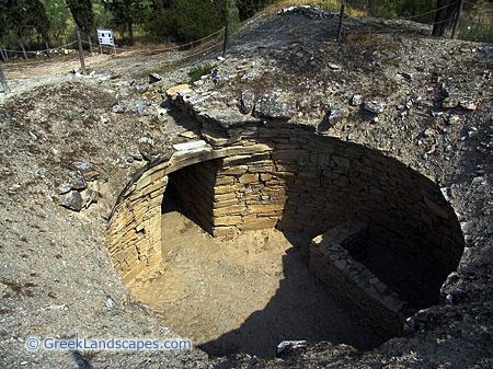
The Mycenean Tholos Tomb (1300 BC)
Photos and Text from Greek Landscapes
The architecture of the 2nd phase at Dimini shows the same
construction methods and same use of materials as seen at earlier
Sesklo. Dimini, however, has a definite fortification system in the
form of 6 or 7 concentric circuit walls. Some of these walls were as
close together as 1 m and may have been rubble filled double-faced
fortress walls. The original number of walls is unknown. They vary in
thickness from 0.6 to 1.4 m, were possibly 2 to 3 m in height, and
were made of rough stone set in mud. The walls follow the natural
contours of the hill and have no corners or towers. At the center and
highest part of the oval shaped hill there was an oval courtyard in
which a megaron type building and a few smaller buildings stood.
Possibly one additional megaron and several additional structures
were scattered within the walls.
Additional text from Tufts
University, Perseus
Volos-Iolkos, Archeological Museum****
The town of Volos is supposed to be the mythical Iolkos from which Jason (20th cent BC) embarked on the ship Argos to the Georgian Kolchis to bring back Medea and the Golden Fleece.
Photos from the Museum in Volos, the richest collection of finds from Neolithic Thessaly. Exhibits on display include jewelry, household utensils and agricultural tools, originating from the Neolithic settlements of Dimini and Sesklo, as well as clay statuettes and a wide variety of items from the Geometric period.
Other fascinating exhibits include tombs transported in their entirety from the archaeological sites where they were discovered, along with the human skeleton and the offerings placed around it. Just outside the museum there are some interesting reconstructions of the Neolithic houses at Dimini and Sesklo
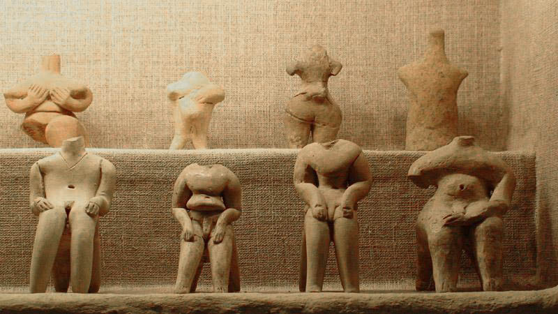
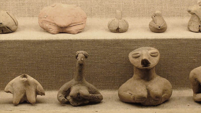
Votive clay figures of the Great Goddess, 7000 - 5000 BC
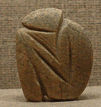
Incised pebble Magoula Karamourlar (Stephanovikio, Magnesia) 6500-4500 BC
Photos from Volos Museum: Phase.com
See also:
Wikipedia, Archeological Museum Volos