The Stones of Greece
The Peleponnisos
The
Morea
Google-Map
A History of the Morea
1207-1699
AD
After the conquest of Constantinople by the forces of the Fourth Crusade (1204), two French Families devided the Peleponnese among themselves. They created the Principality of Achaea, a largely Greek-inhabited statelet ruled by a Latin (Western) autocrat. In referring to the Peloponnese, they followed local practice and used the name "Morea".
The most important prince in the Morea was Guillaume II Villehardouin (1246–1278), who fortified Mistra (Mystras) near the site of Sparta in 1249. After losing the Battle of Pelagonia (1259) against the Byzantine Emperor Michael VIII Palaeologus, Guillaume was forced to ransom himself by giving up most of the eastern part of Morea and his newly built strongholds. An initial Byzantine drive to reconquer the entire peninsula failed in the battles of Prinitza and Makryplagi, and the Byzantines and Franks settled to an uneasy coexistence.
In the mid-14th century, the last Byzantine Emperor John VI Kantakouzenos reorganized the Morea into "Despotates". Sons of the emperor with the rank of despotes were sent to rule the provinces as an appanage. By 1430, the Byzantines eventually recovered the remainder of the Frankish part of the Morea, but in 1460 the peninsula was overrun and conquered by the Ottoman Empire.
The peninsula was captured for the Republic of Venice by Francesco
Morosini during the Morean War of 1684–99. Venetian rule proved
unpopular, and the Ottomans recaptured the Morea in a lightning
campaign in 1714. Under renewed Ottoman rule, centered at Tripolitsa,
the region enjoyed relative prosperity. The late 18th century was
marked by renewed dissatisfaction. Armed bands of the klephts
emerged, undeterred by the brutal repression of the Orlov Revolt.
They waged guerrilla war against the Turks, aided both by the decay
of Ottoman power and the re-emergence of Greek national
consciousness. Ultimately, the Morea and its inhabitants provided the
cradle and backbone of the Greek Revolution (1821).
Wikipedia
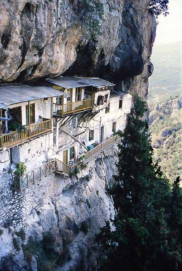
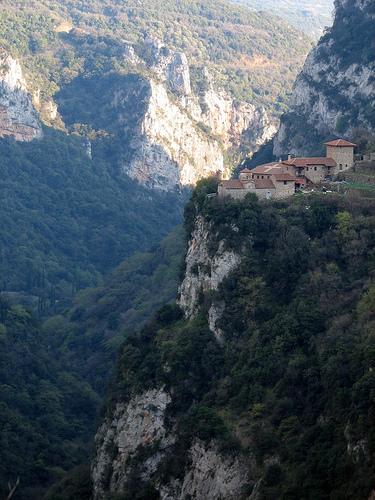
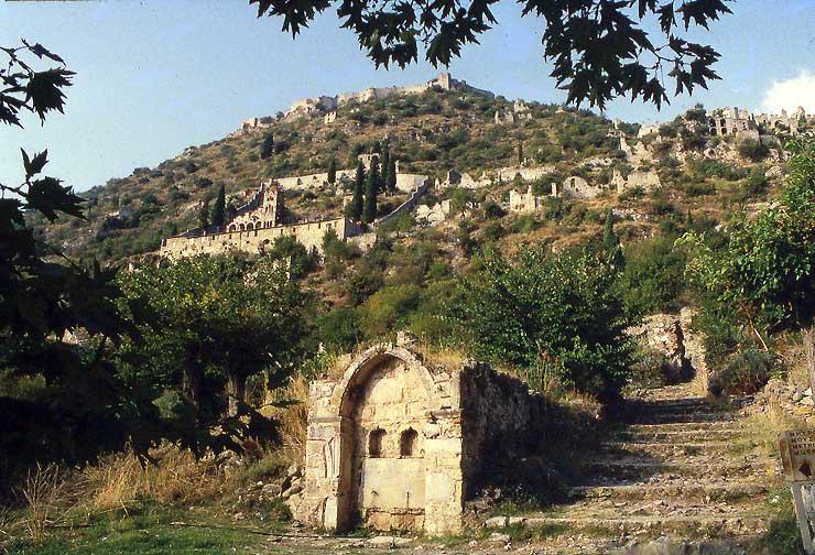
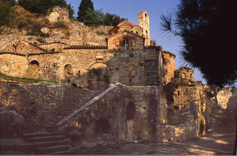
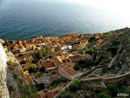
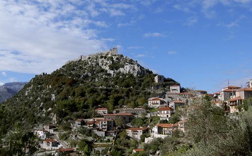
Mystras****
13th-16th
cent.AD
15 km west of Sparta
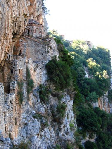
View of Mystras, Villehardouin's castle on top, the
Pantanassa Monastery on the left,
and the Palace of the Despotes
on the upper right, RWFG 1991
In 1249, Mystras became the seat of the Latin Principality of Achaea, established in 1205 after the conquest of Constantinople during the Fourth Crusade, and Prince William II Villehardouin, a grand-nephew of the Fourth Crusade historian Geoffrey of Villehardouin, built a palace there.
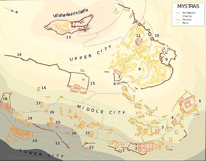
Plan of the city
1. Main entrance ; 2. Metropolis ; 3. Evangelistria ; 4. Saint-Theodores ; 5. Hodigitria-Afendiko ; 6. Monemvasia's Gate ; 7. Saint-Nicolas ; 8. The Despots Palace and the square ; 9. Nauplia's Gate ; 10. Upper entrance to the citadel ; 11. Saint-Sophia ; 12. Small Palace ; 13. Citadel ; 14. Mavroporta ; 15. Pantanassa ; 16. Taxiarchs ; 17. Frangopoulos' House ; 18. Peribleptos ; 19. Saint-Georges ; 20. Krevata House ; 21. Marmara (entrance) ; 22. Aï-Yannakids ; 23. Laskaris' House ; 24. Saint-Christopher ; 25. Ruins ; 26. Saint-Kyriaki
In 1261, the Franks ceded Mystras and other forts in the southeastern Peloponnese as ransom for William II, who had been captured in Pelagonia, and Michael VIII Palaeologus made the Mystras the seat of the new Despotate of the Morea. It remained the capital of the despotate, ruled by relatives of the Byzantine emperor, although the Venetians still controlled the coast and the islands. Mystras and the rest of Morea became relatively prosperous after 1261, compared to the rest of the empire. Under the despot Theodore it became the second most important city in the empire after Constantinople, and William II's palace became the second residence of the emperors.
Mystras was also the last centre of Byzantine scholarship; the Neoplatonist philosopher George Gemistos Plethon lived there until his death in 1452. He and other scholars based in Mystras influenced the Italian Renaissance, especially after he accompanied the emperor John VIII Palaiologos to Florence in 1439.
The last Byzantine emperor, Constantine XI Palaiologos, was despot
at Mystras before he came to the throne. Demetrius Palaeologus the
last despot of Morea, surrendered the city to the Ottoman emperor
Mehmed II in 1460. As Mezistre, it was the seat of a Turkish sanjak.
The Venetians occupied it from 1687 to 1715, but otherwise the
Ottomans held it until 1821 and the beginning of the Greek War of
Independence.
Text and plan from: Wikipedia
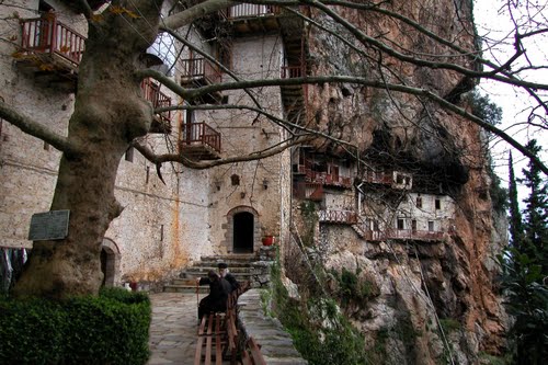
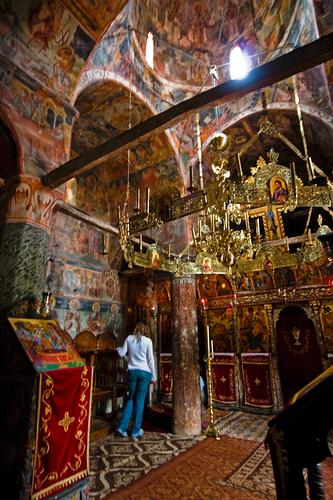
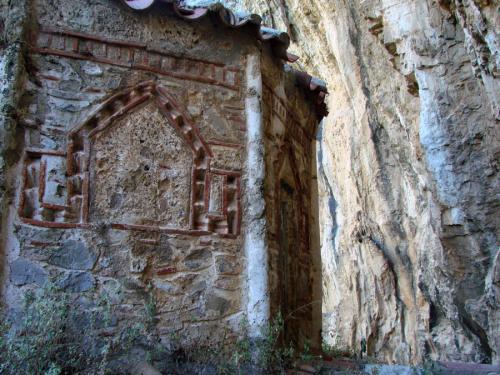
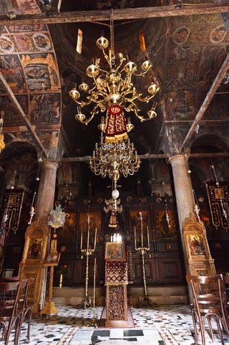
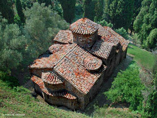
Mystra,
Perivleptos Monastery***
1348-1380 AD
Perivleptos Monastery, RWFG 1991
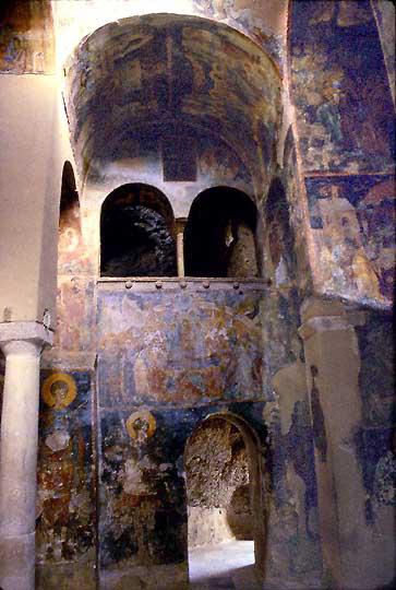
Frescoes in the Katholikon, RWFG 1991
The frescos in the Perivleptos Church, are a rare surviving late Byzantine cycle, crucial for the understanding of Byzantine art.
Monemvasia****
583-1821
AD
Southeast coast of Peleponissos
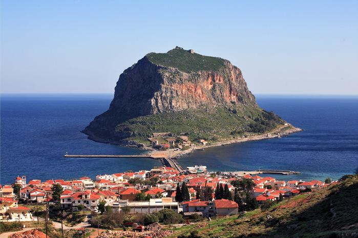
The rock of Monemvassia liveinternet.ru
Entry Gate to the Upper City, Panoramio
View of the Lower City and the footpath up Panoramio
The Colorful History of Monemvasia
The town and fortress were founded in 583 by people seeking refuge from the Slavic and the Avaric invasion of Greece. A history of the invasion and occupation of the Peloponnese was recorded in the medieval Chronicle of Monemvasia.
From the 10th century AD, the town developed into an important trade and maritime centre. The fortress withstood the Arab and Norman invasions in 1147; cornfields that fed up to 30 men were tilled inside the fortress. William II of Villehardouin took it in 1248, on honourable terms, after three years of siege; in 1259 William was captured by the Greeks after the battle of Pelagonia and in 1262 it was retroceded to Michael VIII Palaiologos as part of William's ransom.
It remained part of the Byzantine empire until 1460, becoming the seat of an Imperial governor, a landing place for Imperial operations against the Franks, the main port of shipment (if not always production) for Malmsey wine, and one of the most dangerous lairs of corsairs in the Levant. The Emperors gave it valuable privileges, attracting Roger de Lluria who sacked the lower town in 1292. The town welcomed the Catalan Company on its way eastward in 1302.
In 1397 Theodore I Palaiologos deposed the local dynast of Monemvasia, who appealed to Sultan Bayezid I and was reinstated by Turkish troops. In 1419 the rock appears to have come into the possession of Venice, though it soon returned to the Despot. About 1401, the historian George Sphrantzes was born in the town. After the fall of Constantinople Monemvasia held out against the threats of Sultan Mehmed II in 1458 and 1460, when it became the only remaining domain of the Despot of the Morea, Thomas Palaiologos, claimant to the Imperial throne. He had no forces to defend it; he offered it to the Sultan, and finally sold it to the Pope.
By 1464 the inhabitants found the Pope's representative feeble and the Pope unable to protect them; they admitted a Venetian garrison. The town was fairly prosperous under Venetian rule until the peace of 1502-3, in which it lost its farm lands, source of its food supply and of Malmsey wine. The food had to come by sea or from Turkish-held lands, and the cultivation of wine languished under Turkish rule.
The rock was governed by Venetians until the treaty of 1540, which cost the Republic Nauplia and Monemvasia, her last two possessions on mainland Greece. Those inhabitants who did not wish to live under Turkish rule were given lands elsewhere.
The Ottomans then ruled the town until the brief Venetian recovery
from 1690, then again from 1715 to 1821. It was known as "Menekşe"
("Violet" in Turkish) during Ottoman rule and was a sanjak
centre in Mora province. The commercial importance of the town
continued until the Orlov Revolt (1770) in the Russo-Turkish War,
which saw its importance decline severely. The town was liberated
from Ottoman rule on July 23, 1821 by Tzannetakis Grigorakis who
entered the town with his private army during the Greek War of
Independence.
For once a really nice Wikipedia
article
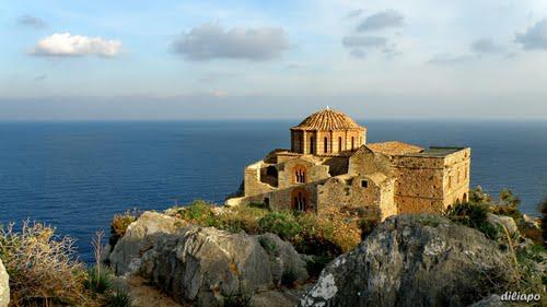
Agia Sofia on top of the Kastro, Panoramio
Monastery
Metamorphosis Loukous***
12th
cent AD
Near Astros on the East coast of the Pelponnissos
The Katholikon of Metamorphosis Loukous, Panoramio
The moni lies to the NW of Astros, in the area of ancient Thyreatis, which is full of antiquities. It was built in the 12th cent on the site of an Early Christian church of the 5th century A.D.
The domed catholicon is decorated with fine wall paintings and its floor is paved with coloured marble slabs. The wall masonry imitates a careless "cloisonne", and includes ancient architectural parts and brick ornaments. The iconostasis is decorated with portable icons datinmg from the 17th century.
The first literary reference to the monastery is in the "Geographica" of Meletios, the Metropolitan Bishop of Athens in 1690. The roof has been retiled, the two-storeyed tower has been supported and the cells have been restored. In the 1980's the painted decoration of the church was systematically preserved and in 1994-95 the mosaic floor of the catholicon was restored. Today the monument is a convent for nuns.
Karytaina**
11th-16th
cent
North of Megalopolis
Karytaina and the castle, Panoramio
Karytaina is a picturesque village in the Lykaion Mountains, located above the gorge of the Alpheios, and topped by a castle. In the Middle Ages it was one of the five Crusader baronies of the Morea. The Castle was built 1209 by the family de Bruyeres who 1320 ceded it to the Palaeologoi. An archway leads into a courtyard. S of which a large hall, a square tower in the north.
The old Frankish bridge across the Alpheios - below the new one - to Karytaina, Panoramio
Agios Nikolaos Church, Panoramio
The Panagia church dates from the 11th Century and houses an
iconostatis painted with birds and ornaments. Agios Nikolaos Church
has five cross-shaped domes, decorated with frescoes that are
unfortunately damaged, however. The chapel of Agios Andreas is at the
western end of the nave of the church.
Wikipedia
Ypsous/Stemnitsa
2nd-16th
cent AD
20 km north of Karyteina,
access to the Lower Lousios Gorge
The Platea in Stemnitsa, Panoramio
Ypsous (ancient Greek name) or with its Slavic name Stemnitsa is a
charming village high above the lower Lousios Gorge. Stemnitsa has
been identified with the ancient Arcadian city Hypsous (Υψούς,
"Up-there"). It was already ruined in the 2nd century AD,
when Pausanias visited the area. It was near Thyraion (present
Pavlia), Zoetia and Paroria. In the 7th and 8th century Slavs settled
in the area and gave it its present name ("Woodland")
Wikipedia
Dimitsana
11th
cent /1821 AD
Village 8 km north of Stemnitsa
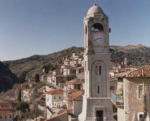
The Clock Tower, Panoramio
Dimitsana
is the entry to the Upper Lousios Gorge.
Dimitsana is a preserved settlement with many Byzantine churches. It
is the birthplace of Patriarch Grigoriou the Fifth and of Paleon
Patron Germanou, whose statues adorn the village today. During the
War of Independence of 1821 against the Turks, the General Theodoros
Kolokotronis used to run here the largest gunpowder warehouse of
Peloponise called “the gunpowder warehouse of revolution for
liberation”. The gunpowder mills of Dimitsana –that are still in
function- used to supply non-stop the warriors of Roumeli and
Moria.
Wikipedia
Lousios
Gorge****
full of old
monasteries
between Gortys and Dimitsana
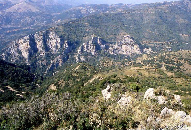
The Lousios Gorge stretches from Dimitsiana to below Ypsous. We only visited Aghios Ioanis Prodromos in 1991. From there we scrambled down into the Gorge. Where we found a very old nymphaion where Barbara took a dip. There is a bridge across the Lousios at the end of the trail. Several other monasteries were visible upstream. Photos RWFG 1992
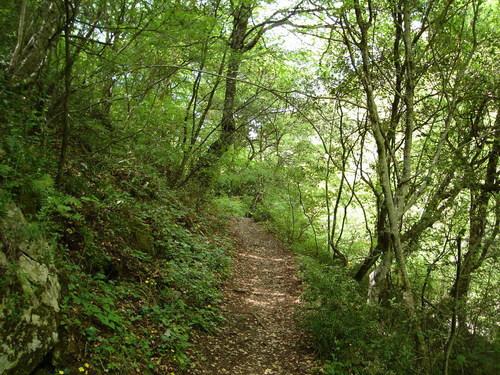
A path on the western side of the river leads to the two Monis Philosophou and to Dimitsana. A beautiful and interesting hike. There are many photos of the Lousios Gorge and its monasteries in Panoramio (on GE) and in the following travel album
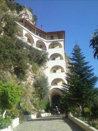
Lousios
Gorge, Moni Aghios Ioannis Prodromos**
17th cent AD
The Moni of Aghios Ioannis Prodromos is the easiest of the monasteries in the Lousios Gorge to reach from Stemnitsa
|
The cells of the monks are precariousy suspended from a vertical
rock wall |
|
Lousios
Gorge, Nea Moni Filosofou**
17th
cent.
|
Nea Philosophou, Photo: ishock/flickr |
Interior of the Katholikon, Panoramio |
Nea Moni Filosófou can be reached from Dimitsana by car. It dates from the last years of the 17th century and was recently restored. The monastery possesses magnificent frescoes of the Cretan school by Victor the Cretan (1663
Palea Moni
Filosophou***
963 AD
|
|
Ruins of the
old monastery of Philosophou |
Palea (Old) Moni Philosophou was founded in 963. It was built in a natural erosion of the escarpment, which can hardly be distinguished from the rock. Because it was so well hidden and inaccessible, it was during the Ottoman domination one of the educational centers where Greek traditions and the Orthodox religion were virtually undisturbed preserved and passed on. It was known as Kryfó Scholió (ie Hidden School . The church is fairly well preserved, and has a beautiful octagonal dome, but of the monastic buildings only the walls survived.
Alifeira,
Moni Panagia Sepetou*
11th
cent AD
14 km east of Andritsaina (Bassae)
Recently restored, Photo Panoramio
Built in the 11th century A.D. on a sharp rock overhanging the river
Tritona, a tributary of the Alfios. Opinions vary concerning the
origin of the Monastery’s name, Septo a verbal surname of "I
respect", or from the Slavic "sopot" which means
waterfall.The Monastery’s contribution to the people of Orthodox
faith was great through the years of Ottoman domination. The
Monastery’s contribution during the Greek revolution was big as
well. It can be visited either by following the road from
Andritsaina, or from Anc.Olympia and Dafnoula the latter being a more
difficult road but also more impressive.
Visit
Greece
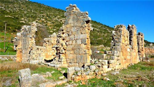
Cistercian
Monastery Isova
1235
27
km west of Andritseina (Bassae)
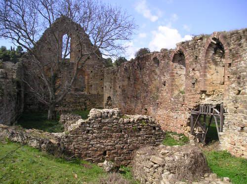
The church, Panoramio
The Gothic church of the ruined
Frankish monastery at Isova in the Peloponnese, was built after the
Fourth Crusade and inhabited by French Cistercian monks. The
surviving structures, unsignposted, are near the modern town
of Trypiti. Together with the ruined churches of the Villehardouins
at Andravida and the ruined monastery of Zarakas, the buildings are
the best examples of surviving Gothic architecture in the Peloponnese
Wikepedia
Andravida,
Aghia Sophia*
1246-78 AD
66
km southwest of Patras
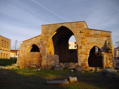
Agia Sophia, Panoramio
Under Geoffrey I Villehardouin (1210-1228/30), Andravida became the seat of Bishop Oleni I. This height of prosperity and influence attained by Andravida was soon overshadowed by the growth of Glarentza in the 14th century, when Glarentza (harbpr) became the commercial centre of the Peloponnese and the most important port leading to the West.
According to the Chronicle of Aragon, William II Villehardouin
(1246-78) built the churches of St Sophia, St Stephen and St James
there. In fact, the church of St James predates 1214, where Geoffrey
I and his family were buried.
gothicmed.es
Chlemutsi**
1220-1223
AD
14 km east of Andravidia
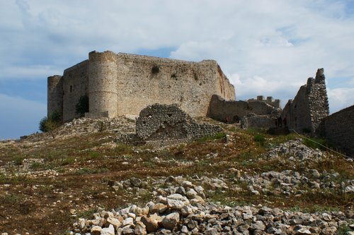
Chlemutsi Castle the Stronghold of the Vilhardouins, Panoramio
The castle was built between 1220 and 1223 during the rule of Geoffrey I of Villehardouin, using confiscated church property.
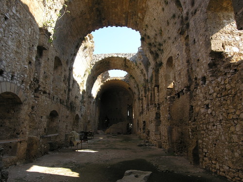
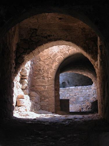
Interior of the fortress, Panoramio
After the death of Geoffrey II Villehardouin, the castle followed the fortunes of the Principality. The Catalan Company under Ferdinand of Mallorca took it in 1315, but he was defeated a year later by Louis of Burgundy.
In the beginning of the 15th century, the castle passed into the hands of Carlo I Tocco. Through his marriage with Maddalena Tocco Constantine Palaiologos (the future last Byzantine emperor) gained possession of Elis, including the castle. Constantine established his court there, and it remained one of the seats of the Despotate until its capture by the Ottomans in 1460.
The Republic of Venice conquered the Peloponnese in the Morean War,
with Chlemoutsi falling into Venetian hands in 1687. Venetian rule
was brief, as the Ottomans recaptured the area in 1715, and held on
to it until the Greek War of Independence in 1821.
Wikipedia
Zarakas,
Cistercian Monastery
1225
Stymphalia,
65 km southeast of Corinthos
Ruins of the Monastery by the road to Koiliadas-Fenou (Achaia)
The monastery was built by monks of the Cistercian Order, in c. 1225. What is particularly noteworthy about this monastery is that it is the only one actually built by the Cistercians in Greece (out of the approx. 17-19 houses throughout Greece), since in all other occasion the Cistercians occupied existing Greek Orthodox monasteries that had been abandoned by the Greek monks.
In this respect it is one of the exceptionally few samples of western Gothic architecture in Greece, along with the (most likely Benedictine) monastery of Isova in the western Peloponnese (just north of the village of Trypiti).
Archaeologists believe that the abbey had been built in the same
location, or general area as an Ancient Greek temple dedicated to
Artemis, which is supported by the fact that materials from a temple
have been extensively used in the buildings of the monastery.
Wikipedia
Tigani
Castle*
13th cent AD
In
the Inner Mani
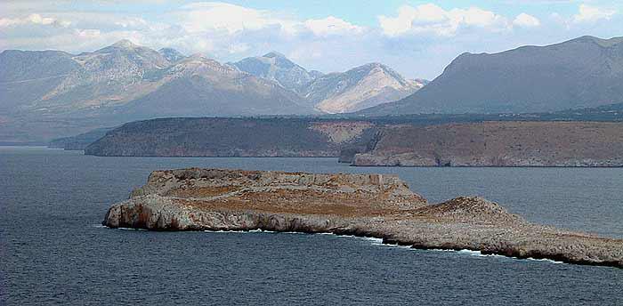
The castle on the “Panhandle” Peninsula, Photo John Chapman
Tigani is a mysterious castle and city (est. 600 souls) with a Gothic cathedral, a monastery, graves of the monks like in Montmajour.... So far nobody seems to know whether it was built in the 9th or the 15th century! It lies at the tip of a surrealist peninsula.
I subscribe to the romantic reading that Guillaume II Villehardouin (1246–1278) bult this castle for one of his mistresses.... Cornelius and I walked there and nearly got lost in the stalacmites and salt ponds along the foot path. There is no shade. Take plenty of water along, there is not a drop.