The Stones of Greece
The Peleponnisos
Messenia
Google-Map
Nestor's
Pallace,
Pylos****
Late Helladic before
1200 BC
Northern Messenia, 15km
southeast of Gargallianoi
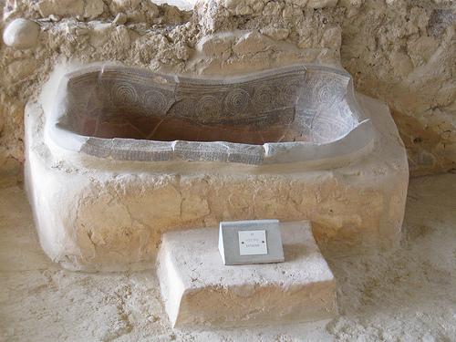
The royal bathtub!
Pylos, located in mainland Greece on the southwest coast of the Peloponnesus, is the site of one of the most important Mycenaean settlements. It is considered one of the best preserved and best excavated of the major palaces. It dates to the late Helladic period before 1200 BCE.
Pylos was excavated recently by Carl Blegen. The excavations revealed a large palace. This was given the name the Palace of Nestor because of its similarity in location to the palace of the King Nestor named in the stories of Homer. The palace is characteristic of Mycenaean palace construction.
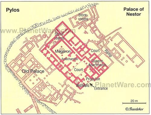
Plan of Nestor's Palace (Pylos)
While the citadel is not fortified, the palace sits on a hill. It consists of many rooms with a large square room known as a megaron at the center. At the center of the megaron is a large circular hearth and on the east side there is a place for a wooden throne. To the left of the entrance there are archive rooms, where many Linear B tablets have been found.
There is also evidence of an upper floor and many rooms including
pantries and large storage rooms. The east side of the palace is
thought to be more residential and it has a smaller megaron called
the Queen’s Megaron. The palace at Pylos is known for the bright
fresco paintings which have been found on the remains of the palace
walls. These include such images as a stylized octopus, a procession
and a fighting scene known as the Tarzan fresco.
Text and plan
from Proteus Brown
U
Voidokilia Bay***
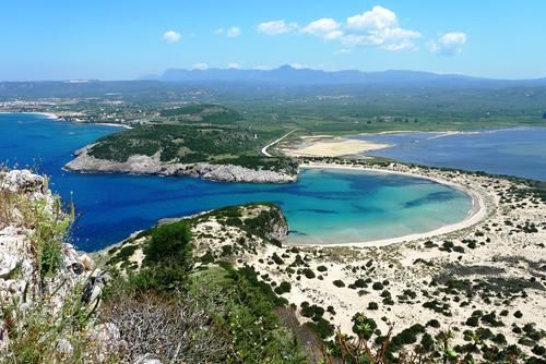
Voidokilia Bay viewed from the Mycenian cemetery. The Hill of Paleokastro is across the bay. Panoramio
The beach is presumed to be Homer's "sandy Pylos" where Telemachus was welcomed by King Nestor when searching for his father Odysseus. The lagune (on the right) is a bird sanctuary, and the beach is considered friendly to nude and gay tourists. Mosquito Warning!!
Voidokilia
Bay, Mykenean Cemetery*
Neolithic/Mykenean
4000-1060 BC
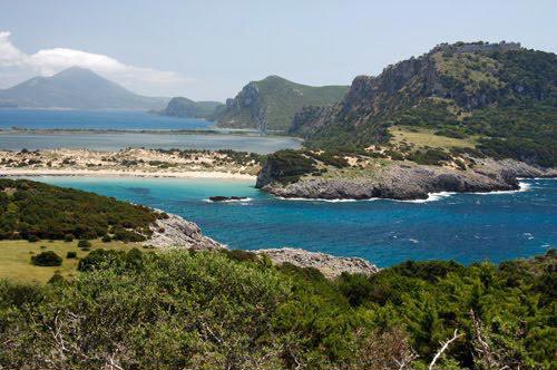
Voidokilia Beach and the Hill of Paleokastro from the Mykenean cemetery. Panoramio
At the northeastern end of Vidokilia Bay is the tomb of Nestor's son, Thrasymedes, and a cemetery from the Mycenaean period (1680–1060 BC). Neolithic finds at the same site show occupation as early as 4000 BC.
Voidokilia Bay, “Nestor's Cave”*
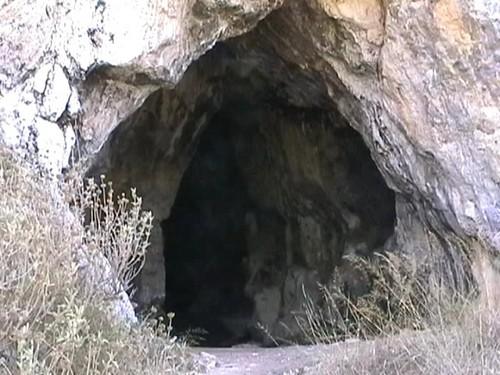
Entry to Nestors Cave, Panoramio
According to legend, Nestor's Cave is where Hermes hid the cattle stolen from Apollo.
Voidokilia
Bay, Paleokastro-”Old Pylos”*
Castle
13th cent AD
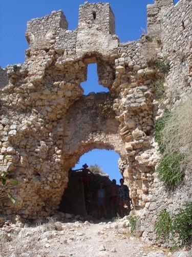
Paleokastro (Enter at your own risk!) Panoramio
Above the beach is Nestor's Cave and above this are the ruins of 13th-century Frankish castle (Old Pylos castle or Palaiokastro)
Ancient Messeni***
1200
-369 BC
Near the village of Mavromati, Southern Messenia
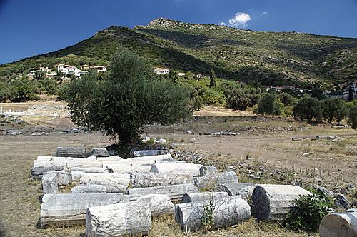
Ancient Messene and Mt. Ithome, Panoramio
The extent of the excavaions is clearly visible in GE.
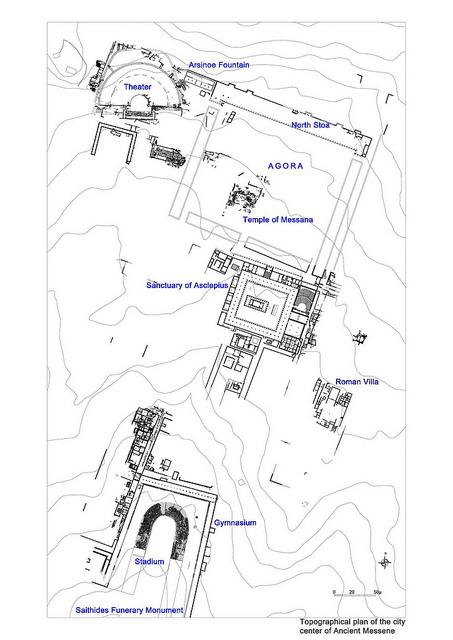
Plan of the Sanctuary
The present ruins at Messene go back to 369 B.C. founded as the capital of liberated Messenia by the Theban general Epaminondas, after the battle at Leuktra (371 B.C.). Systematic excavations conducted by the "Archaeological Society of Athens" brought to light the city-centre with all its architectural complexes, public buildings, sanctuaries, funerary monuments and urban villas, as well as numerous artefacts, notably statues, inscriptions and coins.
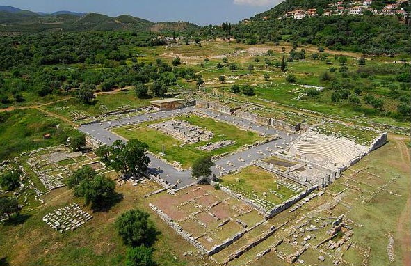
The prize-winning conservation effort to restore the Asclepios Sanctuary
Efforts concentrated on the conservation, restoration and enhancement of the excavated area and its monuments, which aimed at giving them their original form and rendering them both accessible and understandable to the general public.
Among the monuments consolidated, conserved and restored, are in
particular the Stadium-Gymnasium, the sanctuary of Asclepius, the
temples of the goddess Messana in the agora, and Artemis Limnatis and
Eileithyia on the slope of Mount Ithome, the Fountain House of
Arsinoe, and several funerary monuments located within the
walls.
Text, photo and plan from flickr
A
more critical text is found at Wikipedia
Messeni,
Mount Ithome***
2000 -369 BC/ 14th cent AD
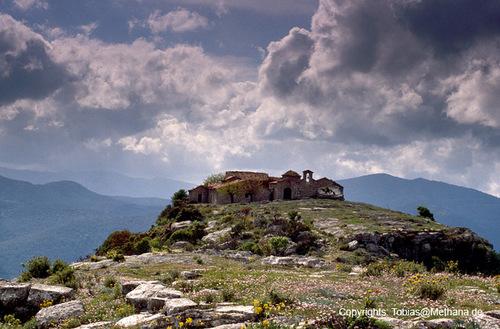
Old Moni Vourkanou on top of Mt. Ithome, the former acropolis of Messene. Remnants of the city walls, a gate, and the Zeus temple are close to the uninhabited monastery. The Artemis temple is near the road clearly visible in GE.
The Homeric village of Ithome was probably on the
summit, which is flat. In the Bronze Age, a temple dedicated to Zeus
Ithomatas (Zeus of Ithome) existed there. It was torn down and
rebuilt as a Christian church and monastery no later than the early
14th century from the same stones. In the 17th century this monastery
of Panagia Voulkanou, or Moni Voulkanou, was closed, except for a
caretaker, to become known as the Old Monastery. The new monastery
was constructed on the lower east slope of Eva. It was a staging
point in the Greek War of Independence and also houses a noted
library containing ancient manuscripts.
Wikipedia
Christianoi*
11th-12th
cent AD
10 km east of Filiatra
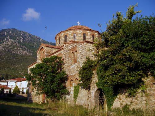
11th century Byzantine Church of the Metamorphosis Panoramio
In terms of architecture, it is the most important Byzantine church of Messenia. It comprises two adjoined buildings, the church and a structure to the west. The church is of the composite, octagonal domed type, distinguished by the careful "cloisonne" masonry, decorated with large stone crosses on the lower sections of the walls. The facades are plain, with very poor brick and sculpture ornaments. Few fragments of wall paintings, dated to the 12th century, are preserved inside the church.
During the Medieval period, the church was the Cathedral of the metropolitan bishopric of Christianoupolis, which was established at the end of the 11th century. The building attached to the west of the church was used as an episcopal palace and possibly as a defensive tower in the Late Byzantine period.
The monument is dated to the 11th or, most likely, to the 12th century A.D. The monument was half-ruined and restored to its present form in 1951. Today it functions as a parish church.
Methoni
Castle**
1204-1821
AD
Southwestern tip of Messenia
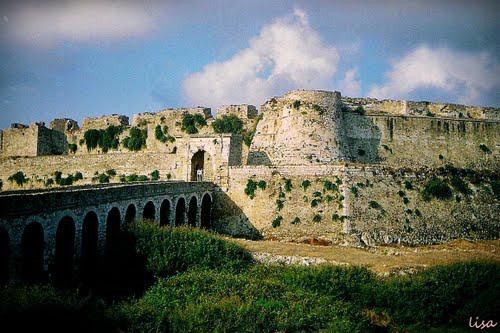
Access bridge to the fortress from the town. Panoramio
Period
of Latin Occupation (1204-16th century) to Ottoman period (1453-1821)
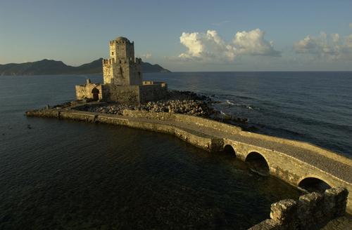
Bourtsi, the southern-most tip of the fortification Panoramio
The walls of the fortress, even though in ruins, continue to be
impressive. The castle of Methoni occupies the whole area of the cape
and the southwestern coast to the small islet that has also been
fortified with an octagonal tower and is protected by the sea on its
three sides. Its north part, the one that looks to land, is covered
by a heavily fortified acropolis. A deep moat separates the castle
from the land and communication was achieved by a wooden bridge. The
Venetians built on the ancient battlements and added on and repaired
it during both periods that they occupied the castle.
Wikipedia
Koroni
Castle**
13th cent
AD
Southeastern tip of Messenia
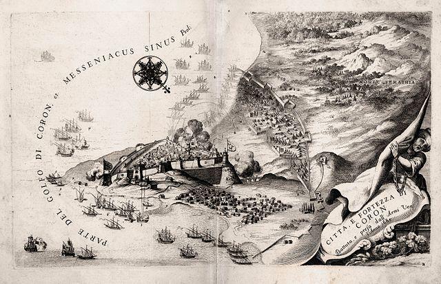
Venitian map of the fortress of Koroni, Vincenzo Coronelli (1650-1718),
The town was founded in ancient times. The Greek geographer Pausanias
in his book "Messiniaka" reports the original location of
Koroni at today's Petalidi, a town a few kilometers north of Koroni.
He also reports many temples of Greek gods and a copper statue of
Zeus. Because of reorderings, in the centuries that followed the town
of Koroni moved to its current location where the ancient town of
Asini had once stood. In the 6th and 7th centuries AD, the Byzantines
built a fortress there. In 1206, the Venetians occupied it, turning
Koroni into an important stage on their sea routes towards the
Eastern Mediterranean.
Text and photo: Wikipedia
Strophades
Islands
40 km east of the coast of Messenia
and
the same distance south of Zakynthos Island
Courtyard of the Monastery at Stamphadi, Panoramio
A group of two small Greek islands in the Ionian Sea. They lie about 44 km (27 mi) south-southeast of the island of Zakynthos. Administratively they are part of the Municipality of Zakynthos. The larger island, Stamfani, is inhabited by one person, a monk who lives in the islands' only structure, an impressive old monastery.
The Strophades were considered the dwelling-place of the Harpies. Virgil states that the Harpies drove the Trojans from the Strophades (Aeneid iii, 209 passim.). The islands are mentioned in The Divine Comedy and in passing in Chapter 10 of Rabelais' Fifth Book of Pantagruel.
According to legend, the islands' name, meaning "Islands of
Turning," refers to Zetes and Calaïs, sons of Boreas, who
voyaged with the Argonauts. Zetes and Calaïs rescued Phineus from
the Harpies. They succeeded in driving the monsters away but did not
kill them, at the request of the goddess of the rainbow, Iris, who
promised that Phineas would not be bothered by the Harpies again.
Zetes and Calaïs were turned back at the Strophades by Iris while
trying to pursue of the creatures.
Wikipedia